History of the Denesuliné (Dene) in Northern Saskatchewan
Author: Anne Mease Page 1 | Page 2 | Page 3
Denesuliné in Treaty Ten:
Birch Narrows (Turnor Lake), Buffalo River (Dillon), English River (Patuanak/La Plonge), and Hatchet Lake (Wollaston Lake)
Birch Narrows (Turnor Lake)
History:
Originally called the Peter Pond band, the Buffalo River Dene Nation (8259.7 h) and the Birch River Narrows Dene Nation (2765.5 h.) were divided into two bands in 1972. Both bands lived in and near Buffalo Narrows before moving to Buffalo Rivers near Dillon and Birch Narrows near Turnor Lake, Saskatchewan.
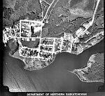
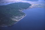
Buffalo Narrows, 1971- Home of Peter Pond Band before 1972 split into Birch Narrows Dene Nation and Buffalo River Dene Nation
Birch Narrows belongs to Treaty Ten signed in 1906.
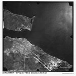
Aerial photo of Buffalo Narrows, SK
Location:
Birch Narrows is located approximately 270 miles from Meadow Lake, which is the closet center with all amenities. They are located about 55 miles from Buffalo Narrows and both communities remain closely connected.
Population:
The population in 2005 for Birch Narrows was 596. Approximately two thirds of the registered population in Birch Narrows resides on reserve.
Language:
The majority language spoken in Birch Narrows is English. It is reported that Denesuliné is rarely spoken and is a language considered in crisis. There appears to be very little done at this point to revitalize the language. This could be attributed to their remote location.
Education:
Birch Narrows Dene Nation has its own school, the Birch Ridge Community School. They accommodate both First Nation and Metis students from kindergarten to grade nine. There are approximately 170 students attending the school on a full time basis.
Birch Narrows has recently taken control of their Educational management from the Northern Lights School Division. There are plans in the very near future to construct a brand new state of the art school in Birch Narrows.
Birch Narrows has a high number of people attending post-secondary institutions across the province and across the country.
Religion:
The Roman Catholic faith is the most practiced religion in Birch Narrows with small minority practicing traditional forms of spirituality.
Organization:
Birch Narrows Dene Nation are governed by a Chief and four Councilors who are mandated by a custom electoral system under Section 10 of the Indian Act (1876). They are affiliated to the MLTC Program Services INC.
Economy:
The community of Birch Narrows gains much of their revenue through tourism. The band owns and operates a successful fly-in fishing camp for tourists and hunters.
The Birch Narrows Dene Nation as with almost all other reserves in Canada receives a transfer payment from the Federal Government. In the case of Birch Narrows, The payment is made to the MLTC Program Services INC and then distributed to the Birch Narrows Band Office. In 2004, Birch Narrows received $3,345,728.00 from the Federal Government in transfer payments.[18]
Buffalo River (Dillon)
History:
(see Birch Narrows history) It is thought the Buffalo River Dene moved from the far north in order to be closer to the fur trading Post at Fort Churchill in the early 1700s.[19] Peter Pond, Thomas Frobisher, and Alexander Mackenzie and Sir John Franklin are some of the well-known explorers known to pass through Buffalo Narrows in the 1700 and 1800s.
Location:
The Denesuliné of the Buffalo River Dene Nation are located on the banks of the Buffalo River between Dillon Lake and Peter Pond Lake in northern Saskatchewan. Their adhesion to Treaty 10 allotted a land base that comprises of 8,259 hectares.
Population:
In 2005 there were 1097 members registered with the Buffalo River Dene Nation. Approximately half of the population resides off reserve.
Language:
The Denesuliné language in the community of Buffalo Rivers is nearly extinct and is considered 'a language in crisis.'
Education:
The school board has introduced the Denesuliné language in their school curriculum in the hopes of increasing the number of Denesuliné speakers in the community.
Religion:
The majority of members of Buffalo River Dene Nation practice the Catholic faith with a small number practicing Protestant. There are few who follow traditional forms of spirituality.
Organization:
Buffalo River Dene are governed by an elected Chief and 5 Councilors. They are affiliated to MLTC Program Services INC.
Economy:
The average income in the community of Buffalo River is $30,837. Many of the employment opportunities arise from the Band Office, labour force, manufacturing and construction industries, wholesale and retail trade, Health and education, and sales and service occupations.
English River (Patuanak/La Plonge)
History:
The English River Denesuliné were previously known as the Grassy Narrow Dene or the 'Polar House People.' There are seven bands of First Nation who belong to the English River First Nation; La Plonge near Beauval (9487.2 h), Wapachewunak near Patuanak (1967 h), Ile A La Crosse (6 h), Elak Dase (1390.5 h), Knee Lake (487.2 h), Dipper Rapids (831.3 h), and Primeau Lake (1690 h). These predominantly Denesuliné First Nation communities are located in the far northwest region of Saskatchewan. Together these seven reserves cover an area of approximately 12,492 hectares.
La Plonge near Beauval
Wapachewunak near Patuanak
Knee Lake
Dipper Rapids
Patuanak was once the location of the Hudson's Bay Company store as it was central to Denesuliné from all over who traded furs.
Location:
Members of English River Denesuliné Nation reside in and near Patuanak, Saskatchewan, which is located west of the Shagwanew Rapids on the Churchill River. The community is situated 50 km from the nearest service center in Meadow Lake and 350 km from Prince Albert.
Population:
There was a total of 1283 registered through the English River Band in 2005. Approximately half of the population lives off reserve.
Wapachewunak reserve has has a population of 434 and La Plonge has a population of 120 of which both these numbers are included in the total census for English River.
Language:
Denesuliné is the first language spoken in English River with English being a second language.
Education:
The first public school in Patuanak was built in 1968. This is the time frame when Denesuliné families began moving from the bush to be closer to the school. Before the school was built the children were sent to the residential schools at Beauval and Ile a la Crosse.
Religion:
Most members of the English River Denesuliné First Nation adhere to the Roman Catholic faith with a small number adhering to Protestant. The first Roman Catholic Church was built in Patuanak in 1916 by Father Louis Moraud who operated it until his death in 1965 built.
Organization:
English River has a Chief and six Councilors to oversee the daily governance of the people. Chief and Council is mandated by Section 10 of the Indian Act (1876). They are affiliated with MLTC Program Services INC.
Chief William Apisis, Chief of the original Grassy Narrow Dene (English River First Nation) signed Treaty Ten in 1906 on behalf of his people. Apparently, "Apisis requested that arrears in annuity payment be provided for all treaty Natives, extending back to the time the first treaties were signed (presumably referring to Treaty One)."[20] There is no mention in Treaty Ten documents to show that Treaty members were retroactively paid.
Economy:
The economy in English River is self-sufficient with many members employed at the Band Office, the Health Center, Education, Broadcasting (local radio station), and in the service industry.
English River owns and operates 'New North,' ' Tron Power,' and 'the Cree Lake Fishing Camp.'
The average income for English River is $30,639.00 per annum. ['Source']
Denesuliné in Wollaston Lake
History:
Description of Wollaston Lake Settlement, from E.T. Russell's What's in a Name?[20a]
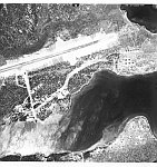
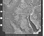
Aerial view of Wollaston Lake
Hatchet Lake was allotted 11, 020 hectares of land through an adhesion to Treaty Ten in 1907.
"In 1796 David Thompson of the HBC surveyed the route from Reindeer Lake through Wollaston Lake, to Black Lake and Lake Athabasca. Here, he discovered a stake set up by Turnor in 1791." [21]
Location:
The Hatchet Lake Denesuliné Nation is located near Wollaston Lake, Reindeer Lake, and Seal River near the Manitoba border. This group of Denesuliné followed the Kaminuriak caribou herds in search of food.
There is no year round road access into Hatchet Lake. There is however, an ice road built across Wollaston Lake to Hatchet Lake in the wintertime and a barge in the summertime. There is a proposal put through in March 2005 to the Federal and Provincial Governments to build a year round road into Hatchet Lake.
There is an airstrip in Wollaston Lake that is easily accessible to Hatchet Lake First Nation but the cost of transportation is very high.
The nearest city center is approximately 480 km away in Prince Albert.
Population:
In 1974, there were 347 residents in Wollaston Lake of which 282 were of Denesuliné descent.[22]
In 2005 the population has increased to 1333 citizens enrolled with the Hatchet Lake Denesuliné Nation. Of the all Denesuline communities they have the highest concentration (1000) of their members residing on reserve.
Language:
The main language spoken in Hatchet Lake is Denesuliné with English as a second language. The school in Hatchet Lake employs a full-time language teacher. Children as well as adults speak Denesuliné on a daily basis.
Education:
Hatchet Lake has an elementary school, the Father Megret Elementary School, which goes up to grade eight and a high school, also named after Father Megret that goes from grades eight to twelve.
Teaching the Denesuliné language to students of all ages is part of the school curriculum.
Religion:
The religious affiliation in Hatchet Lake is a combination of the Roman Catholic and Protestant faith with a minority practicing traditional forms of spirituality.
Organization
Hatchet Lake Denesuliné Nation has a Chief and five Councilors who are elected through band election. They are mandated through Section 11 of the Indian Act (1876). They are affiliated with MLTC Program Services INC.
Economy:
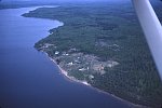
Wollaston Co-op fisheries, plant and boats. 6/71
The economy in Hatchet Lake is steadily improving. Due to its remote location and inaccessibility to the community, the cost of living and transportation is very high.
They have recently built new houses and completed upgrades to other houses.
"The Hatchet Lake Development Corporation has also entered into an agreement with the Saskatchewan Department of Highways to do maintenance work for the airport, local roads, and operation of the barge."[23]
They have constructed a Day Care that accommodates 30 children up to the age of five.
Hatchet Lake Denesuliné Nation received $9,629,827 in Government transfer payments in 2004.[24]
Treaty Initiatives
Black Lake, Fond du Lac, and Hatchet Lake First Nations submitted a Specific Claim to the Office of the Treaty Commissioner in 1993 over a reneged fiduciary duty of treaty rights. This claim is known as the Athabasca Denesuliné Inquiry and includes First Nations from Treaty 8 and 10. The Government maintains that "the Denesuliné surrendered all their rights and interests in lands north of the 60th parallel when they signed adhesions to Treaties 8 and 10 in 1899 and 1907" while the Denesuliné "maintain they continue to have treaty rights to hunt, fish, and trap throughout all their traditional territories, which includes lands in the Northwest Territories, above the 60th parallel."[25] Based on the Government's argument and stance on the original treaty negotiation, the Black Lake Denesuliné and Fond du Lac claim was unsuccessful.
Members affiliated to MLTC Program Services INC. put forth a claim to the Canadian Government for Self-Government. In 2001 they reached a Comprehensive Agreement-in-Principle. Each group will draft their own Constitution that will result in the ability for the different First Nations to create policy to manage their daily affairs. This claim is ongoing.
Endnotes
[18] Lorne Horning, Charted Accountant. Birch Narrows Dene Nation Auditor's Report and Schedule of Federal Funding, May 2004:3. <Birch Narrows First Nation20032004.pdf >
[19] A History of Buffalo Narrows, Saskatchewan <http://www.jkcc.com/evje/history.html>
[20] Kenneth S. Coates. Negotiating the Treaty. Treaty Research Report Treaty No. 10 (1906) Treaties and Historical Research Centre Indian and Northern Affairs Canada, 1986.
[20a] Editor's note: The information about the source of Wollaston Lake's name - that it was likely named for a township in Hastings County, Ontario - is incorrect. Based on research by Bill Barry, the name honours "George Hyde Wollaston, a member of the governor's committee of the Hudson's Bay Co. at the time the lake was visited and named by Peter Fidler in 1807" (People Places: Contemporary Saskatchewan Place Names, 2003)
[21] David Meyer. Human History in Far Northern Saskatchewan.<http://www.lights.com/waterways/arch/archlist.htm>
[22] Community Profile of Wollaston Lake, Sask. R.M. Bone fonds - MG 240 Box 5 I. Northern Sask. Housing Needs Survey. A. General files. Wollaston Lake. Community data - 1971-1975. University of Saskatchewan.
[23] The Hatchet Lake Denesuliné Nation: Community and Economic Development. <http://www.sicc.sk.ca/bands/bhatch.html>
[24] Wilfred Lentz, Chartered Accountant. Hatchet Lake Denesuliné Nation. Schedule of Government Funding, March 2004. <Hatchet Lake20032004.pdf>
[25] Athabasca Denesuliné Inquiry Into the Claim of the Fond du Lac, Black Lake, and Hatchet Lake First Nation. Indian Claims Commission <http://www.indianclaims.ca/english/pub/proceedings.html>