Transportation in the North
Author: Jennifer Jozic Page 1 | Page 2 | Page 3
Thinking about Transportation: The Mackenzie River Valley
A Highway to the End of the World
The Dempster Highway has the distinction of being Canada's first road to cross the Arctic Circle. For 734 km this gravel lifeline winds through Yukon to Inuvik, Northwest Territories. It follows a traditional Gwich'in hunting and trapping trail across three mountain ranges, two continental divides, five rivers and two time zones. The road is gravel but remarkably well maintained although snowstorms can close the Dempster at any month of the year. Car ferries carry drivers across the Peel River to Fort McPherson, a Gwich'in native settlement of 950 people who mix log houses, satellite dishes, tepees, canoes and snowmobiles. A ferry provides a link across the Mackenzie River, providing access to Tsiigehtchic, a hamlet perched on a hillside. When the Peel and Mackenzie Rivers freeze over the Dempster Highway temporarily closes. It reopens as an ice road in early December and shuts down again during spring break-up. In summertime, the highway ends in Inuvik, a town on the coast of the Arctic Ocean coast where restaurants serve caribou and musk ox and the town landmark is an igloo-shaped church. This town serves as a hub for the entire western Arctic. In winter an ice road carries on across the frozen Arctic Ocean to Tuktoyaktuk almost 200 km away.
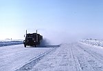
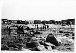
Truck driving on Ice road in the Mackenzie Delta, 1989
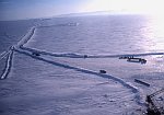
Aerial view of ice roads on the Arctic Ocean, 1989
Living ‘Down North’ with Big Oil
The view from the North is kind of “inside-out”. Southern Canadians think of ships traveling up river from the sea, in order to bring goods to inland communities. But in the western Arctic, ships set out from the source of the Mackenzie River and head downstream to deliver fuel, boats, snowmobiles, and even houses to communities scattered along the shores of the Arctic Ocean. Residents of the Mackenzie River Valley therefore refer to 'going up south' and 'going down north.'
Because of the rapids, barge tows must stop and each barge must be carefully moved through a channel to protect the cargo. Barges are hooked together into a sort of water 'train', and then pushed (not pulled) along by a tugboat. The links holding the barge ‘trains’ together are taken off at Tuktoyaktuk, a harbour on the western coast of the Arctic Ocean.
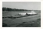
Ship towing Heavy Load, 1960s
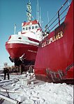
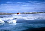
At Tuktoyaktuk Commercial Harbour, 1989
Vast quantities of oil are available near this region. Oil is often found in such remote places, deep under the sea. In order to be processed into gasoline, it has to be transported to an oil refinery. Oil tankers are used to carry crude oil from platforms, and petroleum from the refinery to factories. Oil tankers are huge ships. They are often more than 450 metres long, 60 metres wide and 25 metres deep (the world’s largest oil tanker weighs 564,763 tonnes). The tanker is so long that the crew may use bicycles to travel from one end to the other. A tanker may carry over a quarter of a million tonnes of crude oil. If a spill occurs, it can cause tremendous damage to oceans and wildlife.
Oil drums, 1965
Tanker Unloading, 1965
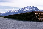
Pipe for an oil pipeline, 1970
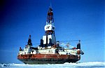
Drilling ship, 1989
Oil companies prefer to transport crude oil to the refinery by using pipelines. In the 1970s residents noticed that the Mackenzie River was suddenly busy with long barge trains. They were carrying drill pipes to the big international energy companies that were seeking oil and gas under the Arctic Ocean and under the Mackenzie River itself.
The companies wanted to build a pipeline down the valley of the river to bring the gas and oil to southern markets. Local native communities were afraid that the pipeline would disturb the caribou herds. The caribou is an important source of food and the hunt is a central cultural event.
The problem was presented to Judge Thomas Berger who decided that the pipeline could only be built after the Government made it clear who owned the land. The Native peoples and the federal government agreed to a ‘land claims settlement’ in 1984. The land claim settlement means that any future energy development or pipeline can be done only with the consent of the Native peoples. Today Native-owned lands cover the entire Mackenzie River area and much of the Beaufort Sea area of the Arctic Ocean.
Conclusion
The majority of northerners live in isolated urban communities. Rugged terrain and extreme climate conditions present special challenges for these people. Creative adaptations, modern aviation and communication technologies have knit what was once referred to as "the great lone land" into a network of communities. Although challenges created by distance and climatic extremes are still daunting, economic and cultural links are steadily increasing between northern areas, southern Canada and the world at large.
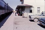
Train Station at Wabowdon, Manitoba, 1960s
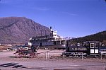
“Yesterday’s Transport Exhibit” on display at Carcross, 1970
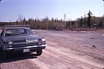
Car on Road to Yellowknife, 1975
Questions for review, based on this exhibit
- What are the two types of traditional dog sled?
- How were dog sleds considered to be a practical method of transportation?
- Give an example that illustrates when a snowmobile would NOT be as practical as a dog sled.
- How are traditional canoes constructed?
- How long was a round trip to northern Canada from Europe one century ago?
- Why was the Canadian government so enthusiastic about airplanes in the 1920s and 1930s?
- Discuss how specialized transportation supports a tourism industry in Churchill, Manitoba.
- Give two reasons why helicopters are useful for fighting forest fires. How have they aided scientific researchers?
- Why do people in the Mackenzie River Valley refer to “going down north”?
- List some advantages and disadvantages of transporting oil with tankers and pipelines.
For Further Information:
- Transport Canada
http://www.tc.gc.ca/ - Transport Canada Youth Portal
http://www.tc.gc.ca/Youth/menu.htm - “All about canoes” at Canoe.ca.
http://www.canoe.ca/AllAboutCanoes/home.html - “Oil, Water and Chocolate Mousse” Environment Canada. Page on
oil spills especially for kids.
http://www.ec.gc.ca/ee-ue/default.asp?lang=en&n=937D1B31 - Canadiana.org page on the Exploration, The Fur Trade and the Hudson’s
Bay Company
http://www.canadiana.org/hbc/intro_e.html
Articles
- Canadian Geographic Kids. It has an excellent page on the Franklin Expedition.
http://www.canadiangeographic.ca/cgKidsAtlas/default_en.asp
“Route of the Gold Rush” Canadian Council for Education website.
http://www.ccge.org/ccge/english/Resources/rivers/tr_rivers_yukonRiver.asp
The Dempster Highway
http://www.yukoninfo.com/dempster/
“Driving the Dempster”. A travelogue from a member of the Canadian Tourism Commission.
http://www.canada.com/travel/story.html?id=bec95a1e-67db-4c73-832f-091b0641afb2
“The Dog Sled in the Northwest” by A. Goffred at northwestjournal.ca
http://www.northwestjournal.ca/IV5.htm